

The Trails Trust is a registered charity and a company limited by guarantee.
It is administered by a Management Board of Trustees. Membership is open to anyone with an interest in the creation of rights of way through a legal process known as express dedication at common law (EDCL).
Express Dedication at common law can be used to create all three classes of rights of way (highways) - footpath, bridleway and carriageway.
Creation of a highway (right of way) by express dedication at common law depends upon dedication to the whole public of a permanent route / rights by the landowner(s) and acceptance by the public. The public shows acceptance through use.
The process offers multiple benefits over statutory creation processes to users, landowners and local highway authorities in terms of reduced costs and liability, expediency and co-operation.
There are a number of useful documents explaining or supporting the process and what needs to be done.
These are free to download and include:-
- 2012 TTT Guide - creating multi user public rights of way - a guide for local groups (R Thompson)
- 2012 Defra Guidance to Natural England on the principles of express dedication (D Waterman)
- 2012 / 2013 Public Inquiry and appeal papers. Inquiry into an express dedicated bridleway at Upper Vobster in Somerset (P Millman /H Cruickshank)
- 2017 The Trails Trust and the Creation of Highways advice note (M White - St John's Chambers)
- 2017 The Creation of Highways (R Thompson TTT in conjunction with the British Horse Society)
- 2018 TTT response to the Agriculture Bill Scrutiny Committee
Creation of a highway through the common law process does not require the consent of the local highway authority (LHA). However once the LHA is satisfied that footpath, bridleway or carriageway rights have been created it is obliged by law to show the new rights / route on the Definitive Map and Statement (DMS). The LHA has duties and powers with regard to the new route, whether or not it is recorded on the DMS.
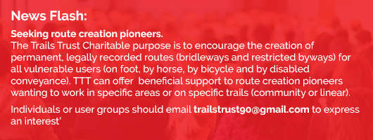
TTT supports and advises groups and individuals seeking to create safe linear or circular community routes by using highway creation as the mechanism for providing missing links, routes required for safety reasons or any other route needed.
Highway creation (if agreed) can happen more or less immediately. Using this process it is possible to:-
- Create an entirely new right of way - footpath, bridleway or carriageway in order to provide a missing link or (for example) over the hedge (safety) route
- Upgrade an existing right of way - for example create bridleway rights over an existing footpath route or carriageway rights over an existing footpath or bridleway route
- Establish a right of way over a corridor of apparently unowned land such as green lanes and droves, negating the need to produce historical or user evidence which may be difficult to find.
- Rededicate an evidence based historic route of any sort- avoiding a lengthy, time consuming DMS application.
This approach was promoted and used in the Government's Paths for Communities Scheme (P4C 2012 - 2014). The scheme promoted the use of the TTT guide "Creating Multi-user Public Rights of Way" to those wishing to create multi user paths (bridleways) through the scheme. (This publication was supported by Natural England and Department for Environment, Food and Rural Affairs).
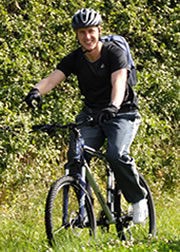
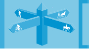
TTT considers that enhanced provision of countryside access is vital for visitors and local people, irrespective of their chosen mode of travel - whether it is with a horse, on a bicycle, on foot or on a disabled tramper.
The benefits of re-building the community network, accessible for all, comprising quiet safe roads, well maintained byways and public paths, on which the public can easily understand where they are allowed to go and do, should not be under estimated.
Path sharing, creating new routes where needed and access to open land is crucial in modern times to provide:-
- Active sustainable travel - reducing carbon footprint, reducing pollution
- Access to landscape and countryside - relieving mental stress
- Sport, recreation and leisure opportunities - providing for a healthier population
- A means of educating the public on food, farming activities and respecting the countryside
- Creating growth in the local rural economy through tourism and farm diversification
- Interaction between friends, families, communities and animals (farm, horse, dog, wild animals) - which is especially important for children.
- Best value - shared routes that more people can share offer best value in improvement and maintenance investment.
Currently the rural network, which should comprise rights of way and minor unclassified (single track) highways is not safe, connected or accessible.
Payment for access - farmers and land owners can be paid for creating new routes and erecting and maintaining gates and maintaining rights of way. Payment should not be paid for existing statutory responsibilities.
The current rights of way / country lane network is seriously affected by three issues. Each prevents sustainable travel in and around the countryside. These issues are roads, routes and rights.
Roads.
Traffic (size, speed, volume) domination prevents, particularly horse riders, but also cyclists and walkers from accessing rights of way.
Most areas are dissected by motorways, trunk roads and other A roads preventing active sustainable safe travel by horse, bicycle or on foot.
Other rural roads (B and C) offer the vulnerable user excessive traffic speeds, blind bends and few safe refuges.
Single track U roads (country lanes) should be considered part of the countryside access network - many are included in the National Cycle Network. However most are subject to the national speed limit (60 mph), may be very narrow with blind bends, have very poor visibility and carry a high volume of agricultural traffic.
There are no local figures for horse use on the roads, however studies in this area have shown that horse riders abandon roads when traffic levels reach > 3,000 movements. The British Horse Society and social media groups show a consistently high and increasing number of horse / rider traffic accidents and death.
In most areas The local OS Explorer Map (data taken from Local Highway Authority Definitive Maps) depicts a minimal and disjointed shared route (bridleways, byways, unsealed unclassified highways) availability (even if one could access them in the first place given the above road data) - and include routes that go nowhere and rights that inexplicably change mid route from bridleway to footpath.
It is widely acknowledged that many rights of way are incorrectly classified as footpath despite historically have been used as bridleway / byway. Applications to amend the County's Definitive Map may take many years and is costly and contentious.
The network over the whole country is very fragmented.
Rights / routes
In England and Wales the (so-called) single use footpath network extends to 101,000 miles this is shared by 9.1 million walkers (who also share the higher right network). Total available walking network = 138,000 miles plus walkers enjoy open and coastal access rights.
Horse riders, carriage drivers and cyclists are denied access to many open access areas which are for walkers only.
The bridleways and byways network is a mere 30,000 miles. Bridleways and byways can be accessed by everyone - 100% of the population, including disabled people - because these routes are accessed by gates or gaps with no stiles. This minimal mileage (assuming one can reach it in the first instance) is shared by an estimated 24 million people who are barred from the 'footpath' network:-
- 2.7 million horse riders (including 500,000 children),
- 7.6 million cyclists(note 500,000 children's bikes sold annually),
- an estimated 500,000 carriage drive and
- 13 million (1 in 5) people who are unable or should not climb a stile (Natural England 2018).
TTT's experience is that even short lengths of new route (newly created bridleways or upgraded existing footpaths) can dramatically improve connectivity. Every OS Explorer Map offers obvious opportunities to link communities and bypass busy roads through upgrades, creations and crossing point provision. TTT has on occasion secured a crucial link by paying landowners a financial incentive to create a crucial permanent route.
Examples
Example 1: A Community Circuit restored in Ditcheat, Somerset. Landowners dedicated 300 metres of public bridleway running alongside the hedge to connect lanes to east and west of the A37. Difficulties in crossing the A37 at this point (60mph limit / average of 9061 vehicles /24 hr, high proportion HGV) The new route allows safe travel and a crossing point for horse riders, cyclists and walkers - reconnecting them with a safe community circuit of 8 miles of linking bridleways and quiet lanes.
Example 2: Communities re-linked. At Upper Vobster, Somerset, farmers and landowners agreed to upgrade a footpath running along a disused railway line to bridleway. This half mile route avoids two miles of dangerous rural road and provides a vital community link reconnecting four communities (Mells, Upper Vobster, Kilmersdon and Coleford). The route is now shared daily by runners, horse riders, cyclists and dog walkers.
Example: 3: A community route to the pub and other rural facilities. Several cross field paths and farm tracks within the Mendip Hills AONB (Priddy area) have been upgraded from footpath to bridleway by dedication to permit safe, sustainable and enjoyable travel for horse riders and mountain cyclists (who are especially keen to visit the Hunters Lodge and Queen Victoria Inns).
Example 4: Access to open access land Thanks to the agreement of landowners, areas of open access land and woodland / forestry within the Mendip Hills AONB is open to horses / cyclists as well as walkers to wander freely on narrow paths and tracks. Inclusion of all users in these areas fosters a sense of community and goodwill, particularly providing safe havens for families to enjoy with children, ponies, dogs and bikes.
TTT considers that, this success represents a tiny fraction of what needs to be done nationally. If we are serious about tackling climate change, enabling sustainable travel, improving health, creating rural economy and jobs and educating people, especially children, about countryside, farming and food, it is imperative that the full potential of the rural access network is realised.
We must reconnect communities, farming and the environment by enabling and encouraging people to travel to, around, and in the countryside by rebuilding, rebranding, and enhancing, maintaining and learning to share the network.
Countryside access routes including the country and urban lanes that lead to rights of way need to be properly maintained, which is not the case currently. All routes need to be waymarked, signed and mapped in a way that the public can understand and find easy to follow.
Gates and stiles are there for the benefit of the landowner and farmer for stock control and should be properly maintained. Any structure that is not needed should be removed.
Landowners and farmers should be supported through a payment system to ensure that public routes are accessible, waymarked, with maintained surfaces - such as annual grass cutting in season.
Local Highway Authorities, relieved of the rights of way maintenance burden should ensure that unclassified single track roads (sealed and unsealed) are properly recorded maintained and signed.
Government has a unique opportunity to gain the crucial participation and co-operation of landowners, farmers and land managers through a payment system or other grants for the creation of new permanent access routes.
There is huge scope to create a countryside access network that the public can access and use, whilst addressing the concerns of farmers.
TTT Recommendations
Create a joined up network of accessible shared inclusive routes for all sustainable users by providing financial assistance through subsidy for:
1) The creation of new multi user routes (bridleway / byway) where needed.
2) Route maintenance i.e. that which is normally carried out by Local Highway Authorities. This should not include payment for landowner / occupier statutory responsibilities towards rights of way.
3) Upgrade of a significant mileage of the under-utilised footpath system to include other users. This gives Best Value and reduces Local Highway Authority Definitive Map Modification Order queues. Many LHAs have queues representing decades of work at present rates.
4) Open up open access land and woodland for multi-use either spatially or along linear routes.
5) Preserve unsealed unclassified county roads which are crucial safe corridors in the network through a blanket byway classification recording on Definitive Maps and Statements (as was done for RUPPs to a blanket Restricted Byway reclassification) (Gives Best Value plus avoiding LHA DMMO claims.)
6) Apply speed limits and driver aware signage (be aware of horses, cycles, walkers) on unclassified county roads which are also crucial safe corridors.
7) Have a national policy of multi user route sharing (best value) for all sustainable travellers (foot, horse, cycle) on rights of way and purpose built tracks and paths.
8) Reduce road accidents and provide public education and clarity by simplifying rights of way and other shared paths, roads or routes nomenclature. For instance - replace 'National Cycle Route' with 'National Byway Route'.
Amend BOAT (Byway Open to All Traffic) to Byway. The confusion of routes known as Byway Open to All Traffic (BOAT), Restricted Byways (RB), Unsealed unclassified county roads (UUR) (Other Routes with Public Access (ORPA), Unclassified County roads (UCR) purpose built cycle ways / multi user paths (MUP) would all become byways (add qualification of sealed / unsealed / restricted). Thus educating the public and giving confidence of where one can go and what to expect.
The term 'byway' will then become synonymous with a route / network where sustainable travel takes place and where motor vehicle drivers expect horses, bicycles, walkers and no one sustainable user dominates.
9) Consult with users as well as local authorities, local access forums and landowner / farmer representatives on how these recommendations might be achieved.